


It’s no secret that Lowell of long ago was more rural, especially in its outskirts – which included the land where Cross Point, Showcase Cinema and Route 3 now sit today. As you drive along Lowell’s Route 110 East today (also known as Chelmsford Street), you’ll cross into Lowell just before you pass under Route 3. From there, you’ll continue past a gas station, a strip mall or two, and local landmarks like Cross Point and Lowes. It’s pretty familiar scenery, even if you’re seeing it for the first time.
In Lowell of long ago, however, stately trees once towered over a white picket fence that lined a rural, tree-lined version of this road.
Lowell’s City Farm was also tucked into this corner of the city, sharing the crescent-shaped plot of land between Chelmsford Street and River Meadow Brook with the Lowell Water Works, roughly tracing the route that the Lowell Connector runs today, between exits 3 and 4.
“I’ll meet you by the break in the white fence.”

Victoria Street once extended across Chelmsford Street and provided the main entrance into the City Farm, described by 19th century Lowellians as ‘the break in the white fence’. Rumor has it that that break in the fence was framed by ‘several thousand’ cabbage plants, but the Victorians were known to exaggerate their descriptive facts.
At the end of its long driveway, you’d see the buildings of the City Farm, standing roughly where Lowes is today. Its land ran from the present-day location of Route 3, back into the Showcase Cinema area, including land where the 99 and Lowes now sit, and up along Chelmsford Street, almost to Plain Street.
“You’ll send me to the poor house.”
Maybe you’ve heard the expression “You’ll send me to the poor house.” Lowell’s City Farm has been gone for years, generations, but it lives on in memory as a shelter of last resort.
City farms served as Victorian society’s equivalent of today’s homeless shelters, nursing homes, and mental hospitals. Lowell’s City Farm, its grounds, buildings, and inmates, was often described as clean and neat. It wasn’t lost on many that some of the poor found at the farm were experiencing some of the best fortune of their lives. But, their original purpose, never strayed far from officials’ minds. The city farm’s main purpose was to instill a sense of self-sufficiency in the paupers of the day.
As one Lowell City Overseer of the Poor put it:
“The philosophy of this method of relief [of the poor] is that it tends to prevent total pauperism. The poor temporarily deprived of labor and its fruits are aided until they are able to become self-sustaining once more. If when their day of trouble comes they are removed to an almshouse, that self-respect which separates poverty from pauperism is apt to be broken down and the person relegated to the increasing ranks of public charges. It has been the aim of the Secretary to discriminate between those whose poverty is the result of untoward circumstances beyond their control, and those whose poverty is the result of untoward circumstances beyond their control, and those whose wretched condition is the result of drunkenness and idleness. The former class have been helped cheerfully an wisely, while the latter have been, as far as possible, compelled to go to work or removed to an almshouse. An effort has been made to extirpate chronic pauperism among a class of idle, worthless people.” Joseph Smith, Secretary of the Overseers of the Poor, 1889.
Finding your way around.

Lowell’s City Farm was no small institution. Its 125 acres housed an almshouse for the poor, a workhouse used to imprison criminals, the insane asylum, and “the House for the employment and reformation of Juvenile Offenders in the City of Lowell”.
The Almshouse was the largest of the City Farm’s institutions, housing an average of 250 people at any one time during the year. Most came and went voluntarily, staying mostly for the worst winter weather between November and March. About 10% of the poor farm’s discharges came through death, through common 19th ailments like consumption and debility.
Most of the insane were kept ‘under lock and key’, but a few were restrained with ‘mechanical apparatus’. A large percentage of the insane were reported to be homicidal or suicidal. The City Farm’s insane population averaged about 75 most years.
The workhouse was the ‘house of corrections’ of its day. Housing about 50 inmates at any one time during the year, most were committed for drunkenness. Far fewer found themselves committed there for crimes like larceny, vagrancy, or embezzlement.
The “House of Reformation for Juvenile Offenders” functioned as a sort of alternative school for children found guilty of crimes, most often truancy. In 1888, the house of reformation housed 41 children – 40 boys and one girl.
What was it like there?
If you were to visit the Poor Farm in Victorian-era Lowell, you’d have been surrounded by a lot of old paupers – old by Victorian standards anyway. When families could no longer care for their old or infirm, they went to the Poor Farm, sometimes temporarily, sometimes for the rest of their days.
Whether free or detained, sane or insane, poor farm ‘inmates’ followed a rigid schedule believed by their contemporaries to be their savior from a life of dependency on the city. All inmates were expected to rise daily at 5:30 in the morning, and retire each evening at 7:30.
All dressed similarly, and slept in dormitories, even if they had been committed there for minor offenses like public drunkenness. They all ate a diet of ‘good, plain’ food. The quarters of those committed there for ‘mental deficiency’ were not quite as ‘commodious’, due to the extra expense that the farm already had to expend on them. The male insane patients worked alongside their sane counterparts in the fields, while the women tended a garden, secluded, and reserved only for them.
Vanished Without a Trace
Today, as you drive along Lowell’s 110, there’s almost nothing left to indicate that the City Farm so dominated this section of Chelmsford Street for generations. The River Meadow Brook, long a key feature of the City Farm’s land, remains, but today finds itself forgotten between the Lowell Connector and the shopping center that hosts Target. You can spy a glimpse of it as you travel along Plain Street near the Connector overpass. The records, a few stories, and fewer photographs are all that remain of an institution that served as a last resort for thousands during Lowell’s 19th-century past.

I had heard people talk about the poor house back in the 1950’s but didn’t know the story. Thanks for the report !
“We’re going to have to move to the Poor Farm!” That’s something I do remember Mom saying more than once when i was growing up. I’m in my 60’s now. I didn’t realize at the time that there really was such a place, but i got the message. I’m sure her parents reminded her as well when she was growing up . And they probably actually knew folks who went there.. ..So just do the right thing and get a job as soon as possible..or else you know what could happen! And me and my brothers and my sister did. The threat worked.
It’s interesting how, years after it was gone, the threat of ending up at poor farm remained.
The directions on the opening paragraph confused me. You are in Lowell BEFORE you go under Rt 3. Nice report in general. I remember hearing the area referred to as “where the poor farm was ” in the 50s and 60s but I never saw any of the buildings. When did they come down?
Hi Jim, Thanks for the comment on the directions on 110. I’ll check that wording. Writing this post was challenging because there’s not much contemporary research available out there on the Lowell City Farm. Victorian era writers just accepted that the poor farm was there, way out in the outskirts of Lowell, and kind of ignored it. I’m planning a follow-up post where I’ll go into some of the census-level patient research I found and a bit more on the day to day there. I need to nail down exact dates, but I’d hazard a guess that the poor farm buildings came down sometime in the 1920-1940 range.
The Lowell City Hospital and Almshouse was located on Chelmsford St, approximately where the Lowe’s is now. From looking at old maps (which can be found the UMass Lowell’s Center for Lowell History)and reading accounts in old issues of the Lowell Sun (found on the Newspaper archive), I was able to piece together that the amlshouse dates from late in the 19th century, sometime after the Civil War. It gradually evolved from a poor farm to a hospital for indigents.
After WW2, there were a lot of requests fromLowell families to name intersections after their sons who been killed in the war. The families of Francis Farris and Joseph Lane vied for the intersection of Pawtucket and School Streets. The honor went to Lane, but Farris got the Chemlsford St Hospital named after him in 1947.
By this time, the buildings were apparently in poor shape, because there was talk in the early 1950’s to build a new Farris Memorial Hospital up on West Meadow Road in Pawtucketville, behind the old Isolation Hosiptal (by now known as Meadowcrest Hospital). However, this never happened – I presume for lack of funds. Times were hard in Lowell in the 1950’s and 1960’s with people and industry alike fleeing to the suburbs or to other parts of the country. WIth a shrinking tax base, it was getting harder for the city to support these institutions.
The city closed Farris Memorial in 1958. Shortly thereafter, the buildings were demolished and the land was developed as an industrial park.
As for Isolation / Meadowcrest, that was closed in 1962, the buildings were demolished, and Pawtucketville Memorial School was built on the site.
That’s about all I know….
Ryan, your directions regarding the city line being just before the overpass heading east on Chelmsford St. is exactly correct. The Entering Lowell sign can be seen just before the bridge. Great job on this article!
Thanks Scott!
I can remember as a child living across Chelmsford Street on Usher St., that the buildings were still there in the late 40’s early 50’s. We kids would go over and visit the pigs that were in pens behind the buildings. Living in the city, farm animals were not familiar, so we were excited to feed them.
Thanks for this article. When my family moved to a house adjacent to the Farris on Wellman St in 1952, the Farris was still operating. I was young, but I recall cows where Lowe’s parking lot is now. A fire destroyed the main building in the mid-1950’s.
I’m sure if I looked at an old census I might recognize a name or two. Tough times in those days.
Hi Judy, I’m planning a follow-up post where I’ll go into some of the census-level detail. I can send you the census sheets if you’d like.
I remember walking by the fence as a child and looking at the poor farm. Thanks for keeping the history of Lowell and Chelmsford alive. So much gets lost nowadays. I am into genealogy and would also appreciate some census-level details.
Were there a set of stone steps in the empty field after the tear down of buildings that were the poor farm?
There were, along Chelmsford Street – right where the Stairway Plaza stands today. I’ve never heard that they were connected with the poor farm. I remember seeing an article years back saying that they were left there by a contractor from a job that was never completed.
The Poor Farm & The Stairs to nowhere.
I lived on Forest Street till 1956, a few streets up from “724” Chelmsford St. at Wellman http://tinyurl.com/y9f88nnh
Somewhere between, I’d say ’50 and that, I remember trekking to the Farm to sing Christmas Carols to kids in old fashioned, high sided, railed cribs and to bedridden “decrepit/frail” old Folks either as a group from St. Stanislaus elementary or the related CYO. Yo, indeed such sights etch in your brain, believe me! (Anyone been out to Tewksbury State Hospital “back in the day”?)
Before the days of the housing in Avenues A,B,C along Chelmsford St., it was a field sloping down to the edge of what we called Hale’s Brook, aka River Meadow Brook apparently today. A great field for running down hill kite flying in the Spring. You could also look across the brook to the mysterious looking Harvard Brewery. On that other side of the brook, you could see a black sided railroad bridge from which you could espy kids skinny dipping in summertime. On winter eves you’d see bonfires dotting the frozen brook. I tried ice skating once, but decided I preferred the warmth of the Hi-Hat on Saturday afternoons and gals in skating skirts vs being in bulky, woolen leggings (not tights of today.) On the south side of the field was a stretch of wild trees leading down to the brook that expanded on its way down to the Poor Farm that was rife with kids (untethered with cell phones) playing Cowboys and Indians…there was even a “humongous”, in those days, boulder titled Cowboy Rock to scamper up. Indeed, the Brook was quite wide if you can envision the Connector covering most of it. It was filled with cattails and other submerged reedy vegetation that if your canvass kayak sank, would easily entangle you and be life threatening…once in a channel/waterway, you couldn’t see the shore! The most common birds were black with red circles on their wings…given the post WWII era and movies, they reminded one of Japanese Zeros! Anyway, the forest/jungle ended at the Poor Farm and “we” only once dared…because of local “mythology”…to creep and peer into the hog sties in the back…there were no pigs that day.
– My best recollection and supposition about the stairs: There was a cute house…kinda cottage style, but not New Englandish(?)…and unlike what is pictured here http://tinyurl.com/y8lzzebd, on that corner. Lest I am wrong, the family who owned the property had at least a couple of same aged boys. Out front, they had put a sand box like many Folks of the era had. To ensure the tots safety, they enclosed it with something like chicken wire fencing. Today, they’d probably get a visit from Child and Protective Services, but IMHO thought it made good sense on “busy” Chelmsford St….LOL
Anyway, I left LowellLand for college in ’58. I’m presuming the cute house suffered some kind of disaster and in razing whatever remained and for unknown reasons, the stairs that I might indeed picture as part of its decor/style, were left behind. To complete the circle of my recollection, I believe Wellman St. would lead you down to The Poor Farm. Amen!
(As an aside, up behind Daley School and overlooking Rte3, there was another area to play Cowboy and Indians that also had a “humongous” Boulder. It was known as Parker’s Pasture and near the rock was a tiny streamlet to (dangerously) quench our thirst lest we forgot to bring an Orange Crush to go with our PB&J with marshmallow Fluff sandwich and Wyse Chips. Speaking of cow patties, I can only presume this is where teens got them to place in paper sacks to set on porches lest one didn’t get a Treat on Halloween!)
Thanks for sharing the childhood memories in great detail! Hard to imagine all of that once happened there. Kids need more places like that today.
I understand the stairs were a form of advertisement for pre fabricated concrete stairs in the early 60’s which were being sold by the man who owned the dilapidated home that stood there for many years. I grew up in the projects off Chelmsford Street from 1964 to 1985
The large rock was in a deserted sand bank we called “the Hole” The name we gave the rock was Elephant rock. The was in the late 50’s. The rock and most of the Hole was covered by the Connecter
I’ve got a post started on census-level detail. I’ll have it live soon.
I would love to see that! My father told stories about having to live on the poor farm when he was a teenager and they weren’t very good memories for him. 😦
Those lonesome steps were much newer than the farm .I worked for Wang in the Courier Building adjacent to them . I have a couple of pictures of them and me on them – but still a mystery who left them there . This is a wonderful article – so interesting . Thank you so much for posting it .
The “steps” were an advertisement for a pre-cast concrete stair and tank company that had its sales office on that site.
Thank you for the information about the steps . Kind of more fun to have a made up mystery but it’s good to know .
Ryan, I just came across your piece! So interesting! I have been looking for information about the Farm for the last two years!! I have some information but your piece is full of details! You mentioned you would be doing a follow up article. Would love to read it. My great grandmother past away at the Poor Farm in 1897 and I have been researching her story for the last year or so! Look forward to hearing from you. Thank you!
Best Regards?
Mary den Boggende
The stairs were there because of the Tread Co. That was down the hill to the left had a husba nd who worked there. It was to promote their
Stairs and treads.
No, AAA stair tread was a subsidiary of the British firm that bought out Lowell Safety Tread in the mid-1960s. They built the new building off Wellman St. at that time. This was about 10 years before the stairs. I worked there for a couple of summers, 1965 1966. The owner was Hugh Siefert. One day in 1966 his lawyer came to visit and brought along one of his other clients, Jack Kerouac.
The lot on the corner with the stairs was owned by my uncle, Albert Levasseur. He once had part ownership of Elliott’s in downtown Lowell. He and his wife were childless. They also had a house on Westford Street . Both houses were filled with junk. A nice guy, but very eccentric. He ran for Lowell city Council several times, never winning.
Hi Kate,
My name is Mary den Boggende – you can get some information from The Overseers of The Poor in Lowell. The Greater Lowell Geneology Club gathered information on The Poor Farm and it is now available. You can contact Lowell Historic Board, 375 Merrimack Street, Second Floor, Room 55, Lowell, MA. Their number is: 978-674-4144. You can also do a search on your computer “Overseers of the Poor” Collection/Lowell Geneology Club. Let me know if I can give you more information. Hope this helps!
I also worked there American mason safety tread,, and a foundry, the stairs were there for years .. i worked there for 7 years.. i might of know your husband.
I lived on Wellman st in 1960’s and worked at the stair tread company when it first moved to the area. It happened when the local American Mason Safety Tread company was bought out by a British firm. The owner was Hugh Seifort. The stairs on the corner of Wellman and Chelmsford were there long before. My Uncle owned the property and let a different company put the sample stairs … probably for some payment. He drove a cement truck for EA Wilson’s so he probably had contacts from that.
Wow That was a terrific article. Spent a lot of time as a kid in that area never new the poor house existed or I just don’t remember hearing about.
Now every time i go to Lowes I will be thinking of the poor house.
Thanks!
I too spent a lot of time around Chelmsford St. as a kid and never knew of the poor house.
Jim did you deliver the “Sun” along with your dog as a kid?
Yo Ryan, “Happy New Year” LOL….Just thinking…time to yank your chain: Might you be straining to do an addendum in terms of Tewksbury State Hospital in terms of goals and the indigent….contrasting, overlapping, interfacing?
Hi Bob – that might be an interesting post. I have an older post on the Billerica poor farm, which isn’t far from the Tewksbury line. I’ll look into a Tewksbury Hospital post.
Wasn’t there a poor farm in chelmsford too? Not too far from the lowell one? At the corner of billerica rd. and 129. Where the barn and old house on the corner? I heard there’s even people buried there from the farm?
Steve, I believe the Poor Farm was on the Lowell/Chelmsford line. It was in the area of where Cross Point and Lowes is today. It was an extensive farm covering an area of about 160 acres. I am not familiar with one in Chelmsford or in that area. I’m guessing where the Poor Farm was so close to Chelmsford line there was only one.
Mary I believe your right about the poor farm in Chelmsford. I grew up not far from there and my grandmother and great aunts talked about the farm. I know I have read about the farm in articles about Chelmsford but could not tell you which ones. I am sure the historical society would know.
I have a friend who died a few years ago always talked about poor farm he even said he lived there with his brother the brother robbed a bank in lowell and died in prison i wonder where it was he had friends that talked about it too
Yes, pretty much every town had one. See Heli Meltsner’s book, The Poor Houses of Massachusetts.
Well gosh darn it! Some of y’all seem to have good memories. As such, thought you might enjoy participating here http://tinyurl.com/ycndtmt7 about LowellLand as well.
Been to Elephant rock many times. Also Cowboy rock (Daley School woods). I was told the white stairs were owned by the Wilde twins (Forrest Street), whose family originally owned the house. (I can’t vouch for this, but this is what I was told). There was a big abandoned house near (/next-to?) the stair house, which was knocked down to build the Scopus building in the 80’s. We used to go into that house sometimes – very spooky. I remember there was still silverware in the draws. We dared each other to go into the cellar (dirt floor, zero lights, way too spooky). If you went down past Elephant rock, you came to a feeder to Hales brook that went under the Connector. There were lots of crayfish in there. We used to to towards Industrial Ave on the brook and skinny dip sometimes (pretty risky since you could see us from the Industrial Ave bridge if you looked when going over it). I ended up working at Wang in the 3-story towers adjacent to this property many years later – I often reflected on my younger years spent right in that area.
I had a morning paper route (first Herald American, later Boston Globe) that ran from the intersection of Chelmsford/Stevens street all the way to Plain Street. I went to Saint Margarets school, and had to make sure the papers were delivered before I got to school (rain, snow, … etc). I even had to deliver papers when snow closed the schools!
I remember Hales Brook, Elephant Rock. When we were children,We walk every where..I also graduated From St Margarets school..We also would visit Parkers Farm And look at all the animalsWe were so free in those days…We use to go by the dairy on wilder street & buy pints of Chocolate milk.My Grand mother lived on the connor of Shaw St. & Wilder.
‘m’ said…”We walk every where”! Alas, I like to think/appreciate that gives me ‘the legs n lungs’ to make it around WallyMart today…damn cigarettes!!! Seemed like All things were just 2-3 miles…It was almost 2 from Forest St. to downtown or to the Hi-Hat on Princeton Blvd. RE the latter: seemed like 50 (but worth it!) miles per lugging a roller skating case every Saturday afternoon to vie for the attention of some cutie in the precursor of the Mini-Skirt era! (Lo, I couldn’t take Yoga leggins today!) Don’t know what I was thinking when one time when I cut through Parker’s pasture and some woods to get home as a Fall eve approached. Later as a teen and living on Christian Hill, why did I choose all my Steadies “3 miles out” in Belvidere, e.g. best, and worth it, was by Shedd Park? Hated crossing wind-swept Hunt’s Falls bridge! Ok, for 50[?] cents would take a cab home some late nights…LOL
(Lest St. Margarites (of the Hyder era) who have moved may not know, St. M’s is now part of the campus of Lowell Catholic High as evolved out of old St. Peter’s Orphanage. Elsewise, several years ago, the Centennial year(?), I queried staff by email as to how/why/who chose the, IMHO, Spanish architectural motif in a town that I didn’t think had an Hispanic neighborhood way back when nor in “my” era. Alas, no one knew. Out of curiosity today, I checked and discovered a History has been written https://www.stmargaretlowell.org/our-history/ which notes simply: ” The church building, designed in the Spanish-Colonial ecclesiastical architectural style of the American Southwest of the 17th and 18th centuries, was built to seat 1186.” Alas and but how, how does that match up with St. Margarets OF SCOTLAND? As such, can anyone ‘splain that?
Blessings (or Good Vibes) to Y’all for the New Year! (Yipee! I get my Covid shot today at 2!)
I am late to the game here, but any idea where the records from City Farm, particularly the Almshouse, might be located?? Thanks!
Hi Kate,
My name is Mary den Boggende – you can get some information from The Overseers of The Poor in Lowell. The Greater Lowell Geneology Club gathered information on The Poor Farm and it is now available. You can contact Lowell Historic Board, 375 Merrimack Street, Second Floor, Room 55, Lowell, MA. Their number is: 978-674-4144. You can also do a search on your computer “Overseers of the Poor” Collection/Lowell Geneology Club. Let me know if I can give you more information. Hope this helps!
I worked on Plain Street in Lowell for years, at the Walgreen’s. I love this old information, and have since forwarded it to my children;, who grew up in the area . I understand the Walgreen’s is now gone. We have since moved to Ohio.
I grew up on Midland St. The same home my father was born in. Loved the neighborhood. I remember when the housing project went in. I use to get the bus into the city right in front of it. The Harvard Brewery was in back of it. It was a great time to grow up. Live in Fl. now.
Alas Pat, as a neighbor one street over, hope you had a chance to run downhill flying a kite in the field before ‘the project’ went in or played in the “jungle” to the right or (blush) skinny dipped in the brook! Yo, that greater neighborhood of the Highland’s was the Bestest, IMHO…e.g. scroll to Bob KA ’58.
Thank you so much for this information. I grew up on Stevens St. and I remember when carnivals would come to Lowell and set up “at the Poor Farm”. It was so exciting to sit on my front porch and watch all the cars go by filled with people going home after being at the carnival. Obviously this memory was waaaay before the industrialization and development of the Highlands.
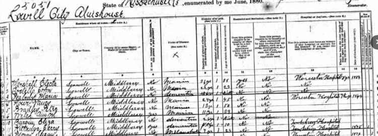
Ryan ,I had family members there from the years ;possibly 1894 to the 1920’s. Ibeleave some passed away there. Is there any pictures or paperwork on any of the people housed at the city farm.
Also, see Heli Meltsner’s book. J. V. Fletcher Library in Westford owns a copy.
Meltsner, Heli. The Poorhouses of Massachusetts, A Cultural and Architectural History (McFarland & Co., Inc., Publishers, Jefferson, North Carolina, and London).
I’m finding this years later from original post. I have been tracing my roots to find my great grandfather was an inmate here do to pauper or illness . He died there after his wife , daughter, and grandson had died all within matter of months . I certainly will follow up on these clues and recommendations. My mother was sent to the Ayer’s home for young women and children as an inmate at age of 7, after all the family tragedy . Outside of where it was located and the large census roll call I cannot seem to find any solid information on it and what it was like there? Any suggestions would be appreciated
I was an altar boy living in the Sacred Heart parish and I recall serving Mass at the Poor Farm, along with my cousin George O’Hare. Father Maguire would pick us up and would have us say the rosary with him on the drive over. It would have been sometime between 1947 and 1950 when I was 9 to 12 years of age. I vaguely recall the long tree-lined driveway leading up to the Poor Farm.